


Marine Ways - Nautical Charts
Beschrijving van Marine Ways - Nautical Charts
Marine Ways Boating is de ultieme applicatie voor navigatie en planning op zee! In deze applicatie krijgt u toegang tot:
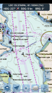
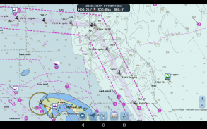
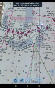
NAVIGATIEKAART
- Kaarten van de Verenigde Staten geleverd door National Oceanic and Atmospheric Administration (NOAA)
- Nieuw-Zeelandse kaarten geleverd door Land Information New Zealand (LINZ)
Grafiektypen:
- NOAA Electronic Navigational Charts (ENC) (NOAA's nieuwste en krachtigste elektronische kaartproduct).
- NOAA klassieke grafieken (inclusief Day, Red, Dusk, Night en Grey versies).
- LINZ-kaarten (momenteel alleen beschikbaar in de versies Day, Dusk en Night)
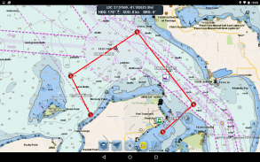
HULPMIDDELEN VOOR ROUTEPLANNING
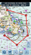
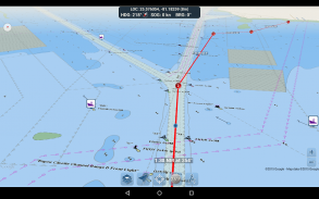
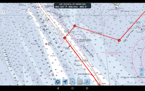
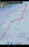
-Route uitzetten. Tik op de kaart en houd deze een seconde vast om uw waypoints te plotten. Om een route te vormen, blijft u in verschillende gebieden op de kaart tikken en vasthouden. Afstand en peiling worden handig berekend en weergegeven voor elke etappe terwijl u waypoints toevoegt, aanpast of verwijdert.
-Reismodus. Centreert de kaart automatisch op uw huidige positie terwijl u zich verplaatst. Gebruik de reismodus om in realtime te zien hoe dicht u uw uitgezette route volgt!
-Route Been Samenvatting. Een handig overzicht met gedetailleerde informatie over elke etappe die u hebt uitgezet, inclusief start- en eindcoördinaten, afstand en peiling.
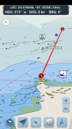
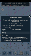
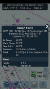
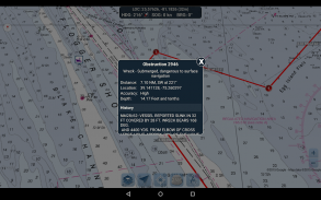
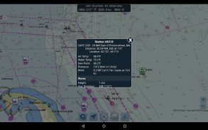
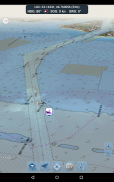
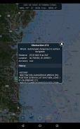
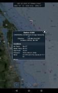
BOEI RAPPORTEN EN OBSTRUCTIE INFORMATIE
Markeringen voor boeien en obstakels zijn handig uitgezet op hun werkelijke locatie op de kaart! Klik gewoon op de marker om hun informatie te bekijken!
- Boeirapporten: krijg volledige huidige omstandigheden en golfrapporten voor vaste en drijvende boeien.
- Obstructies: verkrijg locatie- en geschiedenisinformatie over potentieel gevaarlijke, ondergedompelde gevaren, waaronder rotsen en gezonken schepen.
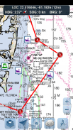
NAVIGATIEDASHBOARD
Het navigatiedashboard toont verschillende realtime informatie, waaronder:
- Huidige locatie (breedtegraad en lengtegraad, met nauwkeurigheidsbereik)
- Huidige koers (inclusief een klein richtingskompas!)
- Huidige snelheid over de grond
- Stroomlager:
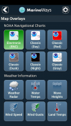
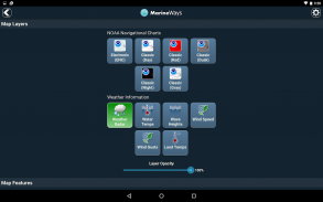
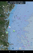
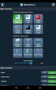
MARIENE KAARTOVERLAYS
Zet verschillende mariene overlay-gegevens rechtstreeks op de kaart om een beter idee te krijgen van de huidige vaaromstandigheden!
Overlays zijn onder meer:
- Wateroppervlaktetemperatuur (wereldwijd)
- Windsnelheden (alleen VS)
- Windstoten (alleen VS)
- Golfhoogten (alleen VS)
LOCATIE DELEN BOVEN HET WATER / BEKIJK ANDERE BOTEN
- Toon uw laatst bekende locatie, snelheid, koers en bootnaam op de kaart zodat andere Marine Ways-schippers ze kunnen bekijken.
- Bekijk de laatst bekende locatie, snelheid, koers en bootnaam van andere Marine Ways-schippers, evenals hun afstand en koers vanaf uw locatie.
- Locatie delen is standaard uitgeschakeld. Wanneer u klaar bent om te delen, schakelt u dit in in de algemene instellingen. Houd de app geopend en gefocust om uw locatie op de kaart voortdurend bij te werken. De app werkt je locatie momenteel niet op de achtergrond bij.
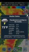
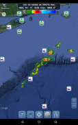
WEER INFORMATIE
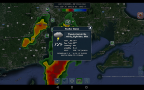
- Weerprecipitatieradar (alleen VS en Hawaï). Detecteert regen en sneeuw in het gebied.
- Weerstation. Rapporteert de gegevens van het dichtstbijzijnde observatiestation. Huidige temperatuur, vochtigheid, weersomstandigheden, wind en meer! Stationsobservatiegegevens zijn wereldwijd beschikbaar.
- Weerwaarschuwingen. Het weerstation meldt ook alle actieve weerwaarschuwingen die zijn afgegeven door de National Weather Service, zoals waarschuwingen voor zware onweersbuien of orkaanwaarschuwingen. Er is weerwaarschuwingsinformatie beschikbaar voor de VS, Alaska en Hawaï.
- Overlay van de landoppervlaktetemperatuur. Toont de huidige oppervlaktetemperatuur op het land (alleen VS).
Voordat u deze applicatie gebruikt, dient u de volgende gebruiksvoorwaarden / service en het privacybeleid te lezen en ermee akkoord te gaan:
Gebruiksvoorwaarden / Service: http://www.marineways.com/appterms
Privacybeleid: http://www.marineways.com/appprivacy
Navigatiekaarten Disclaimer van NOAA:
NOAA ENC Online is niet gecertificeerd voor navigatie. Schermafbeeldingen van de ENC's die hier worden weergegeven, voldoen NIET aan de vereisten voor het vervoer op de kaart voor gereguleerde commerciële vaartuigen onder de titels 33 en 46 van de Code of Federal Regulations.
Geniet van de app! Marine Ways is ook beschikbaar op internet op http://www.marineways.com
Marine Ways - Nautical Charts - versie 1.41
(01-01-2025)Marine Ways - Nautical Charts - APK-informatie
APK-versie: 1.41Pakket: com.marineways.androidNieuwste versie van Marine Ways - Nautical Charts
Andere versies


Apps in dezelfde categorie

Mogelijk vind je dit ook leuk...


